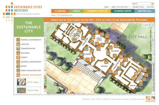
The Home Depot Foundation has completed the updated Sustainable Cities Institute website which I wrote about in a previous post, and can now be found online here.
Randal Birkey created the base map illustration that the interactive Flash application is structured around.
Randal also created the site plan for the City Hall section of the application.
Finally, he created the view of how transportation could be integrated in more sustainable and environmentally friendly ways by city and urban planners.


Hello,
I am writing to inquire about maps you may have available for licensing. We are creating a small direct mail piece (5×7″ range) for a non-profit client. It will be sent to 800 names. We are looking for a map of Chicago that looks illustrated/hand-drawn and it would be especially nice if it contained some amount of detail of the Hyde Park area.
If you have something like that, I would appreciate seeing it and an estimate for this type of use. If you don’t have anything that fits this description but could point me in the right direction, I would appreciate that as well.
Thank you for your time and consideration.